
PilotAWOS
Apple Watch Weather app for Pilots
![]()
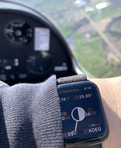
(my copilot spelled me for a moment so I could snap the picture)
An app for Apple Watch with a single, simple function: to show the current weather conditions reported by a nearby Automated Weather Observation Station, typically sited at an airport.
This information is useful to light plane VFR pilots, who normally get it more slowly from a tape loop broadcast on the radio.
PilotAWOS is free to use. All functionality is enabled; nothing is paywalled. There is an in-app purchase option to contribute to the author; it unlocks nothing but the satisfaction of a good deed.
Manual
This is a Watch-Only app, without a counterpart app on the phone.
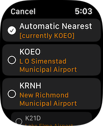
Tap once to choose a station. Swipe left to access Settings or Legend.
This app features a full suite of complications, including styles for all slots. All offer two options: wind barb plus cloud circle, or altimeter setting plus precipitation symbol; except for the largest slot, which combines both.
Weather is re-fetched half-hourly. The re-fetch times automatically adjust to sync with the weather station’s own schedule. A refresh can be manually triggered by pulling down on the main screen.
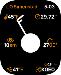
Weather is displayed using a modified Station Model layout: the right-center and lower-right fields hold Cloud Altitude and Station ID, respectively.
The meaning of the various fields and symbols:
- Top left: temperature
- Top right: barometric pressure
- Middle left: visibility distance
- Middle right: height of cloud bases above ground
- Bottom left: dew point
- Bottom right: this observation’s age in minutes, above the current station ID
- If this field shows a “!” alert symbol, the most recent attempt to fetch the weather has failed. This is normal when out of cellular coverage.
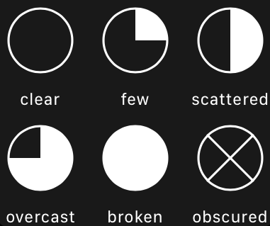
- In the center, a circle that indicates cloud coverage. Empty/quarter/half/three-quarter/filled indicates clear/few/scattered/broken/overcast clouds.
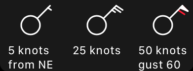
- Radiating from the cloud circle is the wind barb: it points toward the direction the wind is coming from.
- Feathers on the end of the barb indicate speed: 10kt per full barb, in half-barb (5kt) steps.
- Red feathers indicate gusts, e.g.: one white feather and one half-white, half-red feather means 15kt gusting to 20kt.
- If air is calm, an extra circle is drawn around the cloud circle.
- It is very common for this instrument to be offline at a station! In this case the barb is not drawn.
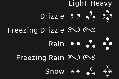
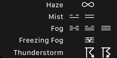
- If precipitation is present, its standard symbols are shown in the area between visibility and dew point.
Symbol Keys:
Wind:
Clouds:
Precipitation:
This app relies on services provided by the US National Weather Service, and as such, is only useful within the United States.
![]()